Enregistrez gratuitement cette image
en 800 pixels pour usage maquette
(click droit, Enregistrer l'image sous...)
|
|
Réf : V02163
Thème :
Cyclones - Ouragans - Tempêtes - Nuages (438 images)
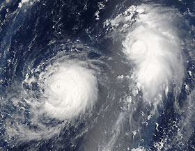
Titre : Typhoon Mawar (11W) and Tropical Storm Guchol (12W
Description : (La description de cette image n'existe qu'en anglais)
Typhoon Mawar (left) is posing photogenically with Tropical Cyclone Guchol in this satellite image. Both storms are far out in the northwestern Pacific Ocean, some 900 kilometers from Tokyo Japan. They are traveling in parallel with each other, both headed roughly northwest at comparable speeds. Mawar, however, will strike mainland Japan on its projected course, and will have built to a Category 4 storm with sustained winds of over 320 kilometers per hour (200 miles per hour) as it strikes shore around August 25. Guchol, however, will never come close to shore if current projections are correct, and will remain a substantially weaker system with peak winds less than half the speed of Typhoon Mawar.The NASA satellite captured this image at 1010 a.m. local time, on August 22, 2005. At this time, Mawar had peak winds around 200 km/hr (125 mph) and Guchol has winds around 100 km/hr (60 mph).
|
|

